Solar eclipse maps show 2024 totality path, peak times and how much of the eclipse you can see across the U.S.
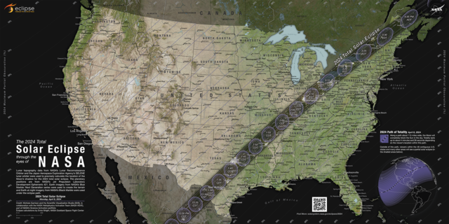
A total solar eclipse crosses North America on April 8, 2024, with parts of 15 U.S. states within the path of totality. Maps show where and when astronomy fans can see the big event.
The total eclipse will first appear along Mexico's Pacific Coast at around 11:07 a.m. PDT, then travel across a swath of the U.S., from Texas to Maine, and into Canada.
About 31.6 million people live in the path of totality, the area where the moon will fully block out the sun, according to NASA. The path will range between 108 and 122 miles wide. An additional 150 million people live within 200 miles of the path of totality.
Solar eclipse path of totality map for 2024
The total solar eclipse will start over the Pacific Ocean, and the first location in continental North America that will experience totality is Mexico's Pacific Coast, around 11:07 a.m. PDT on April 8, according to NASA. From there, the path will continue into Texas, crossing more than a dozen states before the eclipse enters Canada in southern Ontario. The eclipse will exit continental North America around 5:16 p.m. NDT from Newfoundland, Canada.
The path of totality includes the following states:
Small parts of Tennessee and Michigan will also experience the total solar eclipse.
Several major cities across the U.S. are included in the eclipse's path of totality, while many others will see a partial eclipse. Here are some of the best major cities for eclipse viewing — if the weather cooperates:
- San Antonio, Texas (partially under the path)
- Austin, Texas
- Waco, Texas
- Dallas, Texas
- Little Rock, Arkansas
- Indianapolis, Indiana
- Dayton, Ohio
- Cleveland, Ohio
- Buffalo, New York
- Rochester, New York
- Syracuse, New York
- Burlington, Vermont
Map of when the solar eclipse will reach totality across the path
The eclipse will begin in the U.S. on the afternoon of April 8. It will first be visible as a partial eclipse beginning at 12:06 p.m. CDT near Eagle Pass, Texas, before progressing to totality by about 1:27 p.m. CDT and progressing along its path to the northeast over the next few hours.
NASA shared times for several cities in the path of totality across the U.S. You can also
check your ZIP code on NASA's map


 Can’t wait to see the look on her face when I can control matter wit a thought
 Seems like she's not aware or not in tune with her metaphysical Black powers.


.gif")